Four More Years of Support for Our Natural Heritage
As many of you know, the Obama administration has taken a unprecedented stand on connecting people to our public lands and national monuments from its beginning. Today, we at Outdoor Afro are delighted that this effort will move forward and continue in its progress to preserve, protect, and embrace our natural assets and heritage.

Let There Be Light! Or Not?
Outdoor Afro friend Audrey Peterman challenges us in her latest blog to rethink our relationship to nature in terms of our ability to survive natural disaster. Read on:
Among the glaring lessons we should learn from Hurricane Sandy is that our technology-focused lifestyles depend absolutely and completely on one thing – electricity. I often marvel about this, since electricity is extremely vulnerable. One major solar flare or a catastrophic “unnatural” disaster such as Sandy, and a sustained lack of electricity could knock us back to the Stone Age in weeks.
The major problem with this is – the majority of us seem to be completely unaware! Sleep walking! And as we text and tweet and tumble our way through our days, we assume that any loss of power is a temporary inconvenience that will soon be fixed so that we can go back to our mind-numbing pastimes.
But what if it took a month to get the power back? Could you build a fire outdoors and prepare something to eat? Do you know how to purify water to drink? Would you have the means to keep a light burning in your home at night?
These might seem like rhetorical questions, off the chart for someone living in the United States of America. But just ask the people in Atlantic City or West Virginia who have been devastated by fire, flood and snow if they EVER thought that they could face what they experienced this week, and the answer might be sobering.
Not long ago I was part of a meeting sparked by Richard Louv, strategizing how to get children back outside to play and explore n nature. Louv’s book, (Last Child in the Woods: Saving Our Children from Nature Deficit Disorder, 2005) had shown that children’s mental and physical health were suffering as a result of being housebound, tethered to electronic instruments.
One member of the group suggested that we might actually need to teach children how to play in nature, as this generation may not know how. At that moment I felt a chill go through me. I thought, “What can it mean when a species that is dependent on nature has become so removed from it that our offspring do not even know it exists? Or how to interact with it?”
Imagine if we needed to rely TOTALLY on nature, without being able to flip a switch and change cold to heat, or press a few buttons and get help from the world! I do not think it is an overstatement to say, “Sandy is a precursor of things to come, and we’d better get started preparing ourselves.”
Check out a wilderness survival course or other basic course that helps you navigate when the street signs are gone, and electronics are kaput. I’m going to check with my friends at REI to suggest that if they don’t already have a course designed to help people become self-sufficient without electricity, they should immediately institute one.
The time to prepare is BEFORE an emergency. Just ask the people suffering through Sandy!
(Audrey Peterman is a national-award winning environmentalist and the author of the new book. “Our True Nature: Finding A Zest for Life in the National Park System)
Rivers and Waterways: Poll Reveals Caring and Engagement
Survey Confirms a Positive Relationship with Rivers and Waterways in the Outdoor Afro community
Nearly seventy Outdoor Afros from around the country were sampled in a short survey distributed via social networks that provided a snapshot of how and why people connect to our waterways.
Much of what was observed from the results confirmed what Outdoor Afro already knew – that in the Outdoor Afro community overall, there is a positive relationship and perception of our rivers and waterways. Of the sample surveyed, the vast majority were African American, female, and between the ages of 35-44.
Some key findings:
- Participants enjoyed a wide variety of activities on the water that include being on the water, or hiking, fishing, and hunting adjacent to them
- Respondents felt most comfortable getting out on water with friends and family over structured programs
- The biggest identifiable barriers to getting out more was a lack of time and equipment
When asked to describe first introductions to waterways, most surveyed cited early connections to rivers and lakes with family members. And frequently, grandparents and fishing were mentioned.
“Fishing with my grandfather in Kansas... I was the only girl... I loved it”
When asked about what they most valued about our rivers, many used words such as “spiritual” and “calming.”
“Waterways are beautiful. I love the wildlife on and around the water. I love the soothing power of water.”
The biggest concerns and cautions related to waterways? The vast majority mentioned pollution as a big concern, followed by the alarming number of people who do not know how to swim and be safe in the water. And as frequently as we hear about black women having hair barriers around water, only one participant mentioned this as a barrier.

Our survey affirmed that programs have an opportunity to be most effective when they support families to lead one another to connect to waterways that do not require a lot of time. For instance, building awareness of locally accessible waterways for recreation might be one approach to expand connections. Also, find ways to raise awareness of gear rentals, so more people can try activities with minimal investment.
At Outdoor Afro, we will continue to increase the visibility and positive connections to rivers and waterways. Join us to help dispel myths, and inspire more families and communities to engage with these delicate resources -- the nature they are, and all that surrounds them.
Anything surprise you about these results? Have a differing viewpoint?
This survey and blog are sponsored by the Georgia River Network in an effort to increase relevant connections of our rivers and waterways with more communities.

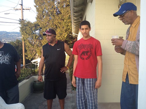
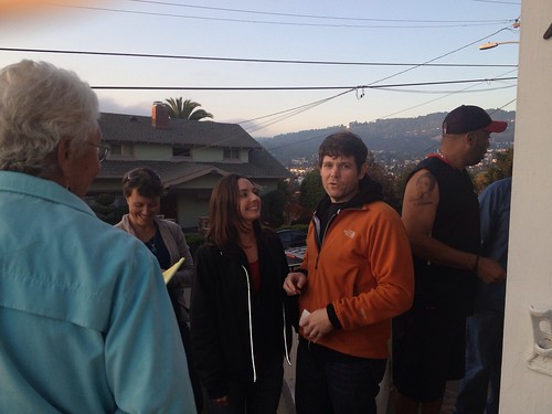
It's Good to Know Your Neighbors
Our family recently moved into a lovely place back in my familiar, and dynamic hometown of Oakland, California. For the previous six years we resided in a nearby small and sheltered community known for its excellent schools, low crime, and civic pride. There, my children roamed free outdoors, and visited neighbors – sometimes well into the evening after dark.

After several weeks of searching, a house found us in Maxwell Park, a well established and diverse urban neighborhood. But after moving in, I soon noticed the absence of children playing outside, imagining that the children who once roamed this neighborhood in days past, now likely had children of their own, rooted in a distant suburb. Our street today, framed by tidy yards tended by retirees, appeared safe enough, but my children expressed their uneasiness about being outside in their new surroundings.
“There is no one outside,” they lamented; and after tossing a ball back and forth among themselves for a short while, would stumble back up the stairs into the house, searching for a screen for diversion. Admittedly, I was weary too. Since I did not know anyone around me, I lacked my usual confidence in letting my kids be their typical free-range selves. I missed my old neighborhood.
Then I had an idea.
I decided to organize our own welcome wagon to meet our community - so my children and I put together this simple flyer below for a Friday meet-and-greet on our front porch.

The prior Monday evening, my daughter and I walked and knocked from door to door a half-dozen houses in either direction of our home. At first, it did feel a little awkward, but without exception people opened their doors to greet us warmly giving way to a feeling of confidence and purpose. For those not home, we conspicuously wedged a flyer between door cracks, railings, and in mailboxes.
Our micro-pilgrimage revealed even more diversity than we imagined. In addition to our meticulous garden tending seniors, we met tech entrepreneurs, a bakery owner with a chicken coop, a school district administrator, a horticulturalist, and many, many dog lovers. But we also made another discovery: children.
My fellow parents were relieved to know another family with children had moved in the ‘hood, and their kids pressed around them into doorways eager to meet a potential new friend.
The evening of our gathering, our first guest said to me with caution, “this neighborhood is kind of particular,” perhaps in an effort to prepare me for a low turnout. Yet soon after our 6:00 PM start, doors opened, and nearly every neighbor we met, and some we had not, mounted our stairs to join us on our porch for a cold drink and a snack.
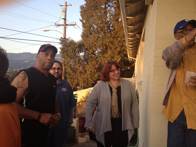
What I thought was a chance for neighbors to get to know our family was much richer, as some neighbors, living nearby one another for a while, had never met in person! So for about an hour, we swapped safety tips, family histories, and almost all reassured, “if you ever need anything, just come over.” That evening, our family became a part of a neighborhood.
Before leaving, my previously skeptical neighbor expressed amazement, and said, “In all the years I have lived here, this has never happened – you did a good thing.” It sure felt like it.
Getting to know our neighbors has transformed our experience in our new place for the better. For instance, neighborly greetings are more warm and genuine, with enthusiastic waves from passing cars, or a lingering “hello, how are you?” As for my children, they now feel more confident about getting outside, and do so more easily. They have since reached out to neighbors to borrow things such as scotch tape, and even freshly laid eggs on a Sunday morning.

What a difference it can make to know your neighbors as part of a healthier and happier community, and to help parents and children confidently connect with their local outdoors.
Do you know your neighbors?
Service Day at Montrose Point Bird Sanctuary
Check out this recent trip report from Outdoor Afro Leader Vi Ama out of Chicago!
Outdoor Afro Chicago volunteer day was held last Saturday at Montrose Bird Point Sanctuary. Montrose Bird Point Sanctuary is a hidden jewel located in Chicago's Uptown neighborhood. The 15-acre property also known as the Magic Hedge Sanctuary was previously leased by the military.
Since the 1980s birders and the city of Chicago have transformed this park into one of the Midwest’s leading parks for bird watchers and migrating birds. The sanctuary includes a bathhouse, sand dunes, beach and pier. Over 300 species of birds migrate to the park during the spring and fall seasons.

What attracts these birds is the location of the park -- the sanctuary prominently sticks out into Lake Michigan, which makes it easy for the birds to spot. The sanctuary includes a mixture of native plants, insects, and wildlife that attract migrating birds. The park is not only for birders and migrating birds, but also for artists seeking inspiration from the landscape and educational tours for kids attending local schools.
Upon our arrival to the park, lead steward, David Painter, notified us of a rare visit by a Burrowing owl at the point. This was Chicago’s second visit from a Burrowing owl; the last visit occurred in 2008. Using one of the birders' scopes, we got an up close view of the owl (here is a great video of the owl's visit and if you're curious about this bird check out www.defenders.org which has a lot of cool facts).
Following the viewing of the Burrowing owl, we assisted in planting the Rose Bush and Hazelnut shrubs, which are both native to Illinois. We also witnessed one of the largest shrubs I have seen being planted, the witch-hazel shrub (see picture below). Following the planting of the shrubs, we received a tour of the sanctuary by head volunteer, Jo Martinec, who has been volunteering for 10 years. From our tour, we learned the city is focusing on restoring more native plants to the landscape. The landscape for the state of Illinois is highly diverse, including: prairies, wetlands, savannas, cliffs of sandstone and lime-stone, beaches, sand dunes and swales. The sanctuary includes prairies, wetlands and other native plants and trees. Restoring native plants assist in restoring the local ecosystem and creating a diverse wildlife.

Our day of service at the Montrose Bird Sanctuary turned into a great day of learning. We learned a part of Chicago history, picked up some planting skills and hung out with some birders. Look out for more Outdoor Afro Chicago activities.
For more photos check out the photo album, Service Day at Montrose Point Bird Sanctuary.
Primary Class Studying Plants: Whittier School
Celebrate our historical connections to nature with this photo from Frances Benjamin Johnston (American, 1864–1952)
1899-1900. Platinum print, 7 1/2 x 9 9/16" (19 x 24.3 cm). Gift of Lincoln Kirstein to the MOMA

Our Point Pinole Hike Was Dynamite!
Guest Blog Submission and photos by Outdoor Afro Leader, Cliff Sorrell of a recent trip lead in the San Francisco Bay Area.
Outdoor Afros recently took on Point Pinole Regional Shoreline in Richmond, CA – it was such a great time! About thirty-five people of all ages and from all over the Bay Area came together to hike, learn the history of Point Pinole, and identify local birds with the help of Golden Gate Audubon volunteer docents.

The hike was approximately 4 miles in length with some gentle slopes. The trail had great views of the inner Bay Area along the shoreline. Along the trail, I was able to point out the different biomes: a vernal pool, salt water marsh, and Oak tree savannah, and share how each biome contains their unique plants and wild life that create their own food chain.
But the history of Point Pinole is very intriguing with regards to its previous land use. Point Pinole is the final home of Giant Powder Company. All along the hiking trails in several locations, were ruins of dynamite bomb shelters and sites of explosives testing.


The most interesting fact is that the Giant Powder Company was founded by Alfred Nobel; the father of the Nobel Peace Prize Foundation. Alfred was determined to stabilize and commodify the use of the dynamite stick, and many died in this effort. He, too, died December 10, 1896, following a severe stroke. Not to be remembered as someone who profited from the development of violent tools capable of death and injury, Alfred left a will with instructions after his death to create an award to recognize new ingenuity for the benefit of mankind - the Nobel Peace Prize. Learn more about Point Pinole by clicking here.
Looking forward to our next Outdoor Afro adventure! Thanks to Golden Gate Audubon and Toyota Audubon Together Green for your support of our adventures!
Upcoming Event: Surfing Possibility with Brown Girl Surf!
Aloha Outdoor Afros!
Did you know that girls around the world from Brazil to the Gaza Strip are taking up surfing and changing the paradigm of women and sports? We’re following some of them on a cool project to bring their stories to the world. We would like you to be a part of it! Join Brown Girl Surf and Storytellers for Good for the KICK OFF Surfing Possibility fundraiser on October 11, 2012 in San Francisco, CA!

Bangladeshi surfer girls!
This Fall, I, along with my friend Cara of Storytellers for Good will be traveling to India and Bangladesh to meet South Asia’s first female surfers. We will share with you their stories and our journey through a series of blogs, short-form documentary profiles and photographs.
We will use the media as educational tools to speak on topics of female empowerment and risk taking in diverse cultures. We will also use it to inspire a culture of diverse, trailblazing women and girls to live in possibility of their dreams!
Our event, held in celebration of International Day of the Girl on October 11th in San Francisco, will be a memorable evening during which we'll share our video trailer, sneak peak Skype interviews with some of South Asia's first female surfers as well as details of our upcoming trip. We'll also be raffling off some cool items like:
- A surf lesson for YOU and 3 friends from The Wahine Project! (Boards, wetsuits and instruction all included)
- Clothes and gear from Patagonia
- Brown Girl Surf gear
- $160 class pass to Aha Yoga in San Francisco
- One FREE surfboard ding repair
- Storytellers for Good T-shirts and more!
RSVP here
If you're not able to join us that evening, we'd be so grateful if you can check out our trailer and support our Indiegogo campaign:
We hope to see you there!
Outdoor Afro Celebrates its Youth Leadership!
By special invitation, the Maryland Coastal Bays Program and Coastal Stewards participated in Estuary Education Day at the U.S. Environmental Protection Agency headquarters in Washington, D.C. on September 27, 2012 in celebration of National Estuaries Day and the 25th Anniversary of the National Estuary Program.

Pictured left to right, U.S. EPA Director of Oceans and Coastal Protections Division Paul Cough with Coastal Steward & Outdoor Afro Youth Leader Tashonna Grant, an 11th grade student at Stephen Decatur High School, who shared information about her local Assateague National Seashore. Way to go Tashonna!
Environmentalism: Nothing New for African-Americans
Submitted by Morgan Powell, a landscape designer, who edits Bronx River Sankofa on You Tube and Facebook. He is passionate about New York’s Bronx River and its African American heritage. Here is his third submission in a series to highlight the generous yet delicate resource of the Bronx River and African American engagement with our environment as a whole.

This blog will address four decades in the life of a ghetto park's stages of development. We'll recognize some of the local leadership whose initiative was founded by a white Catholic activist in 1974. Today, a riverfront park is being rebuilt as a monument to over three decades of stewardship, civic accomplishment and vision that grew from those efforts: West Farms Rapids park along the Bronx River Greenway.
Africans are known to have been taken in as community members by Native Americans throughout the age of North American colonization by Europe. I believe this came out of a mutuality of consciousness -- two traditional cultures creating family for survival.

West Farms Rapids (2 Acres)
The West Farms Community is one of many historic settlements along the Bronx River, which is the only freshwater river in New York City. Measuring 23 miles, this blue corridor has been central to the life of the Bronx since pre-colonial days. It winds its way from the heights of Westchester County to meet the East River at Hunt's Point. Called Aquehung (River of High Bluffs) by the Mohegan Indians who fished and hunted along its banks, the Bronx River derives its name from Jonas Bronck (1600-1643), a Swedish sea captain who settled 500 acres of the mainland in 1639 as the Bronx's first European resident.
While his land extended to the Bronx River, his home overlaid by today's neighborhood of Port Morris, was closer to where the East River bends toward its path to the Long Island Sound. The attraction of beaver fur brought European traders in the early 1600s at a time when Africans were know to accompany some trappers in the region. Soon, the Dutch followed by greater numbers of English settlers arrived.

Mills began to sprout up along "Bronck's River." By the mid-1800s as many as 11 mills were processing paper, flour, pottery, cotton, rugs, barrels, lumber, grains (wheat, millet, corn & barley), gun powder and tobacco, powered by the stream. More than a small share of those raw materials (e.g. cotton and tobacco) were harvested by African-Americans as near as Connecticut and as far away as Louisiana working in bondage and freedom.
The Bronx River Valley's economy grew through the 1600s and 1700s. Farming and cottage industries developed and flourished until the Revolutionary War, when the river became a shifting battle line between American Patriots and British Loyalists. The De Lancey family estate, now part of the Bronx Zoo, is well documented as a site of 18th century tensions. American troops gained control of the area when British Loyalists evacuated in 1783.

During the era between the Revolutionary War and the War of 1812 and again in the 1840s during the construction of the New York & Harlem Railroad, factories sprang up along the Bronx River shores, which harnessed the current to power manufacturing. At one time, at least 11 mills stood between North Castle and West Farms. The Bolton Bleachery for cotton and wool textiles operated for many decades on the same site where the Lorraine Hansberry Academy is now situated at the intersection of Boston Road and East Tremont Avenue.
These industries brought both prosperity and pollution as they dumped their refuse into the waterfront. In 1896, a report by the New York State Legislature stated that the river had become an "open sewer" and appointed a commission to remedy the problem. After intensive study, the commission recommended that the city purchase the land alongside this waterway and transform it from an unregulated zone of farms, slums and factories into a landscaped nature preserve. America's first parkway was thus born, allowing the city and state to control activity along the river and providing motorists, bicyclists and strollers with a pleasant venue for recreation and scenic trips.

The Bronx River Parkway (opened in stages from 1916-1925) protected the watershed as it entered Bronx Park as envisioned by major advocates of it from the Bronx Zoo. However, the Bronx River did not receive dedicated ecological rehabilitation south of East 180th Street until 1974, when Ruth Anderberg founded the Bronx River Restoration Project (BXRR) on the inspiration of then Bronx Police Chief Anthony V. Bouza, who had already launched an intergovernmental dialogue to clean the river. West Farms Rapids (formerly Bronx River Park, originally Restoration Park) marks the genesis of those efforts. The rock-stuffed rubber-tire retaining wall most prominent on the east bank is a landmark commemorating 1980, when this place was officially opened as a park. Around this time, BXRR also created what's now called the Bronx River Art Center (BRAC) nearby and River Garden, and published the Bronx River Restoration Master Plan. This plan advocated the ecological revival of the whole river complete with a continuous linear park from the Kensico Dam to its mouth at the East River.

Many hands contributed to these early efforts, including teen-aged and adult workers and community leaders from Lambert Houses, like BXRR treasurer Marcel Woolery, Jr. Meanwhile, independent efforts to rehabilitate the surrounding community and expand green spaces were accelerating under the leadership of MBD Housing with black icons like Genevieve Brooks and E. J. Mitchell.
BXRR's efforts were funded by city programs like Summer Youth Employment. Housing Preservation and Development (HPD), local elected officials, Phipps Houses, and other organizations dedicated resources for construction, programming and maintenance. In the 1990s, local residents and workers formed a new coalition to revive this site. Called the West Farms Friends of the Bronx River, members included Michelle Williams, Bernard Tim Johnson, Nessie Panton (still active at River Garden), Andre Williams, Juanita Carter (honored with a street sign), Perquida Williams, Sebert Harper (currently a New York City Housing authority tenant gardening consultant) and others.
They organized riverfront clean-ups, planted the park's original butterfly garden and worked with the Parks Department to install picnic tables for family recreation. In 1997, HPD gave the city jurisdiction over this park and by 2008 the Parks Department owned it. Also in 1997, Partnerships for Parks convened the Bronx River Working Group, comprised of 20 founding partners, including Phipps Community Development Corporation, BXRR and the Bronx Council for Environmental Quality. This collaboration culminated in 2001 with the creation of the Bronx River Alliance.

In 2000, the Transportation Equity Act allocated $770,800 to renovate the park. This mid-Bronx node of the Bronx River Greenway broke ground in 2008 to improve safety and enhance multi-modal access, featuring a canoe launch, a new butterfly garden, an amphitheater and direct access to East Tremont Avenue where Bronx Street was absorbed into this park and demapped. The Department of Parks and Recreation of the City of New York, the Bronx River Alliance and community partners continue to maintain this remarkably beautiful and historic site.
Find this park on a map!

More about the author – Morgan Powell is editor and founder of Bronx River Sankofa on You Tube and Facebook. His initiative is part of a local movement to recognize four decades of African American environmentalists & over 350 years of Bronx social history including Afro ethno - botany in the Bronx River watershed. Over 525 folks have attended live presentations of his. Bronx River Sankofa is an independent project of the Bronx African American History Project of Fordham University in partnership with the Bronx County Historical Society.
