7 Bay Area Ridge Trail routes to summer trip plan
Planning a trip to the Bay Area with Outdoor Afro is a guaranteed outdoor adventure. Volunteer leaders guide some of the most enriching events to establish new relationships with natural West Coast wonders. Mountain hikes. Valley bike rides. Beach games. Public land nature journaling. You name it, volunteers have probably guided it. So here’s another adventure to anticipate exploring with the network: the Bay Area Ridge Trail.
Spanning 400 miles, this multicity network of trails offers everything from camping to flower spotting. It winds through San Francisco, Marin, Oakland, Napa, Sonoma, San Jose, the Peninsula, Berkeley, and Fremont. Multi-use pathways meander between the area’s North and South Bay. The idea to develop such a comprehensive trail spawned from a group of outdoor enthusiasts who envisioned an extended option for Bay Area residents, providing epic routes for those itching to discover more of nature from their backyards.
The trail opened in 1989. As of November 2021, 400 miles have been dedicated for public recreational use with another 150 miles opening in the coming years for the same purpose. Once the full 550 miles complete, residents and tourists will have continuous access to more than 75 parks and open spaces. Visitors can go by foot and even horseback through some of the Bay Area’s most iconic and tranquil naturescapes and backdrops. Of course, mapping out such a massive route can become challenging, however the trail’s website offers an easy-to-use system — the Ridge Trail Circumnavigation.
Plan everything from campsite locations and multi-day itineraries to determining the closest parking lots and best locations for a scenic picnic with gal (or guy) pals. Although there are still some unfinished parts to the trail, adventurers can take advantage of the trail’s two long, uninterrupted stretches that are currently open. On the Western Ridge: an 80-mile stretch from Northern Marin to Highway 92. On the Eastern Ridge: a 43-mile stretch from El Sobrante to Union City. View the full database of trail maps to organize summer trips. Fun options for future Outdoor Afro Meetups the network is considering as well. So include these starter locations into this year’s Bay Area travel plans, whether an independent day trip or longer excursion with family and friends:
Presidio to Marin Headlands
Distance: 1.9 miles | Difficulty: Easy
The star to this stretch of trail is none other than San Francisco’s Golden Gate Bridge. One of the less strenuous paths, this short walk also is accessible by wheelchair. As with any bridge, wind conditions are unpredictable, so be sure to carry an extra layer of clothing (scarves or pullovers) to confront extra breezy days.
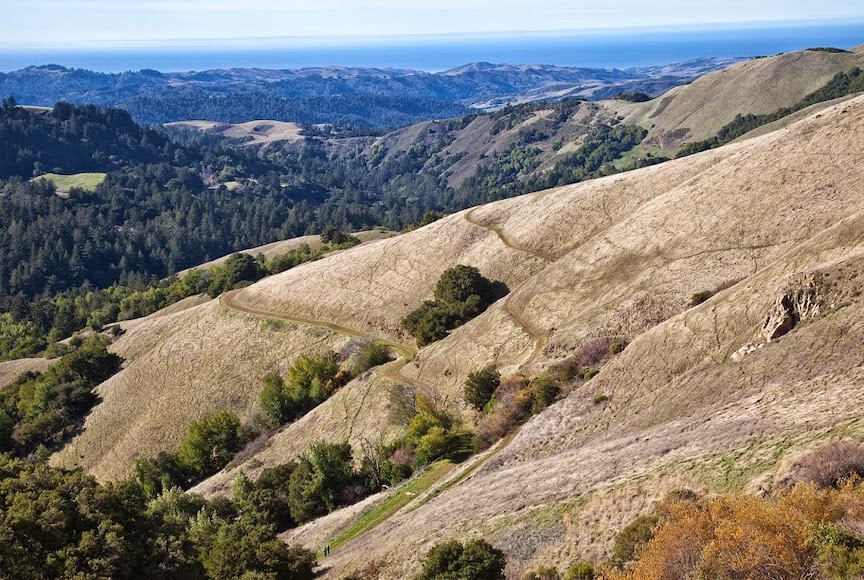
Mount Tamalpais State Park/Bolinas Ridge
Distance: 6.4 miles | Difficulty: Moderate
For those who enjoy smartphone-worthy landscapes, this is the ideal trail section. From blooming wildflowers to ocean view lookouts along each step, this hike may be a little more demanding, but the vista will certainly help keep the trip on scenic course.
Jack London State Park and East Slope Sonoma Mountain
Distance: 5.5 miles | Difficulty: Hard
Challenge seekers: This one is definitely the one. So, bring it. The trail is located within the historic Jack London State Park. During the journey, expect to go through a rather dense forest. The perk while making it through this woodland is calming streams flowing nearby. Reach the highest point of the mountain’s ridge, and scenery typically found in global magazines of Valley of the Moon and the Bay are end results.
Table Rock to Palisades Spur
Distance: 6 miles | Difficulty: Hard
Ever pondered what it’s truly like to ascend to the highest point of the Bay Area? Now is the time to put action behind the thought. It’s often recommended to try this hike between April and June, because that’s also when wildflowers endemic to the area come out to play. See if you can spot the Southern Oregon buttercup, the Henderson’s fawn lily, or the dwarf woolly meadowfoam. To be clear: This trail requires full hydration, so pack enough fluids to keep moving steadily.
Coyote Lake to Harvey Bear Ranch Park
Distance: 5.6 miles | Difficulty: Moderate
This stretch is picnic perfect. Unplug for a couple of hours next to Coyote Lake, which is a popular feeding area for wild bird species like blue herron, red-necked grebe, and ring-necked ducks. Camp around this popular waterway. Easily bring a backpack. Pitch a tent. Plunge into local lake life. Keep in mind there’s very little shade along the trail, so pack sunscreen, a hat, and sunglasses if possible.
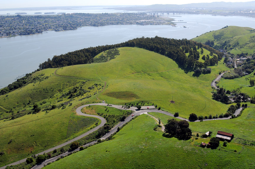
Carquinez Straight Bike Loop
Distance: 24 miles | Difficulty: Difficult
For Bay Area mountain bike riders, this mix of paved roads and pathways connects the Carquinez Straight through a 24-mile loop. Along the way, take in rarely seen cityscapes of the Bay. When it’s break time, there are plenty of eateries and cafés along the route to refuel or restock on snacks and knick knacks.
Mount Madonna County Park
Distance: 3.5 miles | Difficulty: Difficult
This route is entirely uphill, so prepare mentally and physically before attempting. Start from the Sprig Recreational Area trailhead to climb and climb and climb. Pass by boulder-laced grasslands before finishing in a redwood canyon. It’s an estimated 1,150-foot slope, so good luck!